OsmAnd 5.2 (Android)

We’re excited to announce OsmAnd 5.2 for Android!
This update brings extended Marine map style, detailed search results, improvements for travelers and drivers, and reliable cloud autosync for your data — plus lots of other enhancements to make navigation even easier.
Thanks for choosing OsmAnd as your mapping companion!
What's new
- New "Marine" nautical map style with extensive customization options;
- Added street and city details to search results;
- New Trip Recording widgets: Max Speed, Average Slope, and improved Uphill/Downhill;
- Improved map rendering speed;
- Base automatic sync to OsmAnd Cloud;
- Improved OBDII BLE connectivity;
- Updates of "Analyze by Interval" feature;
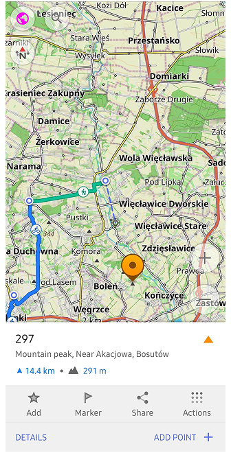
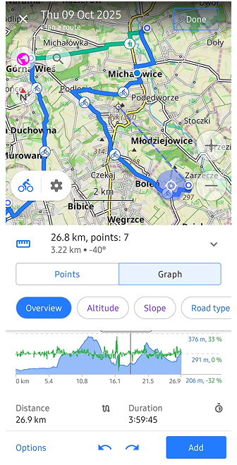
- Improved Plan a Route tool;
- Added the ability to set altitude units separately from distance units;
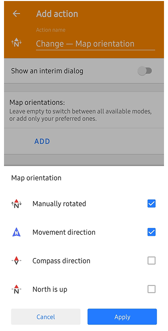
- Improved map orientation quick action with selectable compass modes;
- Android Auto enhancements;
- Inverted screen orientations;
- Improved UI for adding truck metrics in Truck profile settings;
- More parameters for route showing on the map;
- Other improvements;
- Bug fixes;
New Nautical Map Style
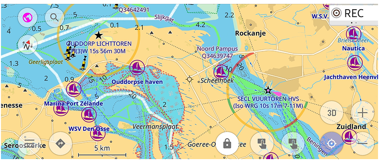
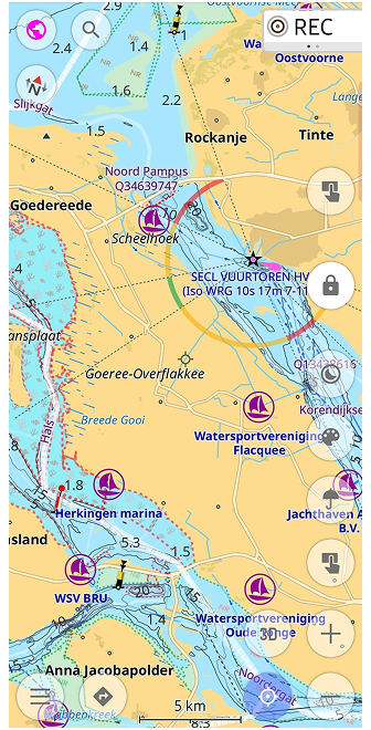
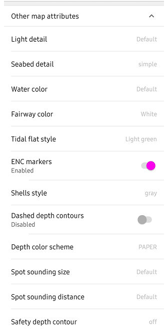
"Marine" is a new nautical map style designed for maritime navigation. This style displays light characteristics, sectorial lights, and other maritime features. The Map Configure menu after enabling "Marine" style has additional options for customization in the "Other map attributes" section.
Search Improvements
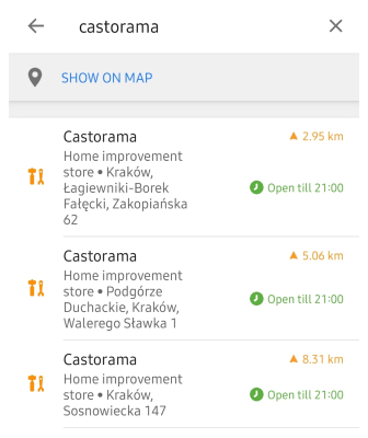
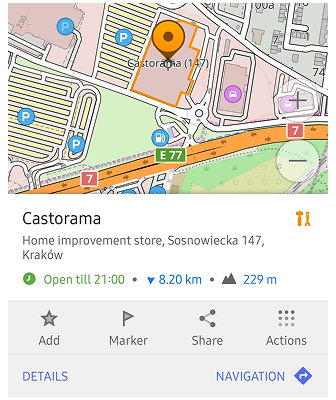
Search results now include city info and address details, making it easier to find specific locations.
New Trip Recording Widgets
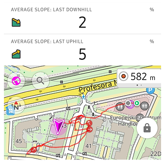
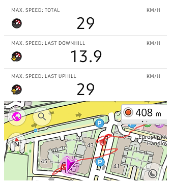
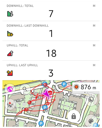
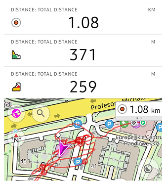
New widgets for Trip Recording include Max Speed, Average Slope, and an improved Uphill/Downhill widget that now shows total ascent and descent:
- Average Slope widget displays average slope for the last downhill or uphill section of the recorded track (can be set in settings or by tap to the widget).
- Max Speed widget shows the maximum speed reached during the recording. Tap to switch between the overall max speed and the max speed of the last uphill or downhill (or choose modes in settings).
- Improved Uphill/Downhill widgets, now its can show or the sum of all ascents/descents, or the last ascent/descent of the currently recorded trip.
- Distance widget shows total distance of the recorded track, with modes to view the distance of the last ascent and descent.
Map Rendering Speed
We have optimized the map rendering engine (OpenGL) to improve performance for rendering maps and map elements, resulting in a smoother experience when navigating and interacting with the map.
Base Autosync to Cloud
OsmAnd now supports base automatic synchronization of your settings and data to the OsmAnd cloud, ensuring that your data is always backed up and accessible from any device.
Menu → Settings → OsmAnd Cloud → ⚙️ → Auto-backup
Improved OBDII Connectivity
-
OBDII BLE adapters can be connected to OsmAnd.
-
OsmAnd reconnects automatically to OBDII adapters.
Battery and Adapter Voltage
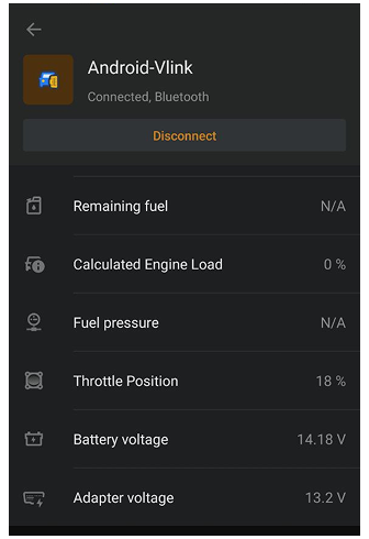
Added battery and adapter voltage display when connected to an OBDII adapter.
US Parameters for Fuel Consumption
Added US parameters for fuel consumption, allowing users to view fuel efficiency in US gallons per hour, US gallons per 100 miles, and Kilometers per US gallons.
And for Remaining fuel: Volume (US gallons)
Improvements for "Analyze by Interval"
Added Heart Rate Metrics
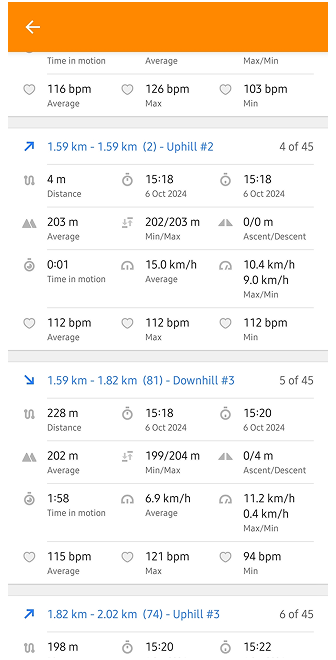
If your GPX track contains info about heart rate, you can now monitor your heart rate during activities with the "Analyze by Interval" feature. You can see your average, maximum, and minimum heart rate for each interval and for the entire track.
Added Downhills/Uphills Analyze
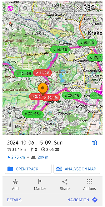
Now, you can split your track for analyzing downhills, uphills and flats segments.
Improved Plan a Route Tool
-
Added the ability to add POI / Favorite as a via point directly from the map when using the "Plan a Route" tool.
-
Show duration for the entire route in the Graph section.
Altitude Units Setting
Users can now set altitude units (meters or feet) separately from distance units in the settings:
Menu → Profile Settings → General Settings → Units & formats → Altitude (Meters or Feet)
Map Orientation Quick Action
The map orientation quick action has been improved, allowing users to select between different compass modes: Manually rotated, Movement direction, Compass direction, and North is up.
Android Auto Enhancements
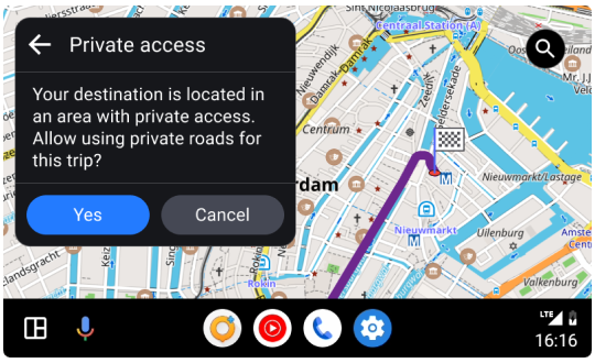
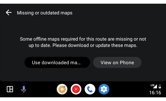
- Now dialogues show about missing maps and private roads before starting navigation like in the mobile app.
- Added support for pinch to zoom gesture on the map.
Inverted Screen Orientations
Added support for inverted screen orientations, allowing users to use the app in various device orientations:
OsmAnd menu → Configure profile → General Settings → Screen orientation → Landscape (inverted), Portrait (inverted)
Improved UI for Truck Metrics
Now, you can add special truck metrics for Truck profile directly from the profile settings:
Menu → Configure profile→ Navigation Settings → Vehicle parameters: Max axle load, Max weight at full load
More Parameters for Routes
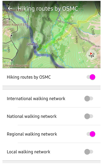
Now, you can choose more parameters for routes selection. For example, you can select Hiking routes by OSMC of Regional walking networks.
Other Improvements
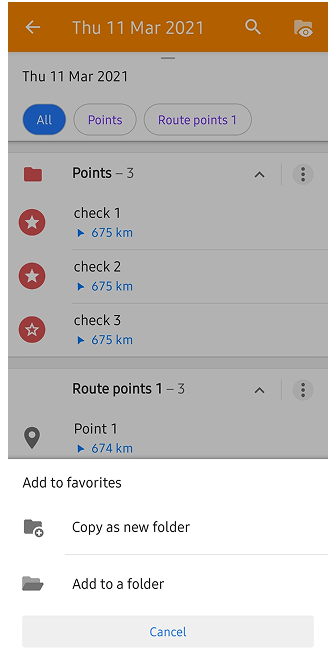
Updates copying Waypoints
Added option to copy waypoints between different Favorites folders or create new ones.
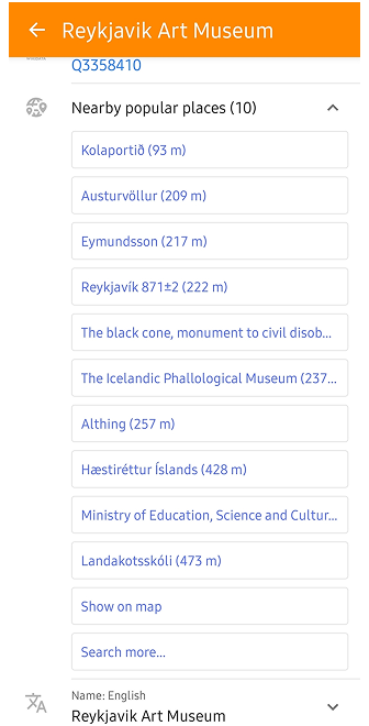
Popular Places for Point Context Menu
The context menu for POIs and Favorites now includes a "Popular Places" section, making it easier to find and navigate to frequently visited locations.
Improved Actions for Audio Note
The stop record action for audio notes have been added with external device, and the ability to start-stop record audio notes only with external device.
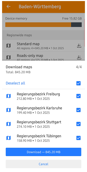
Improved UI for Multiregion Download
The UI for downloading multiple regions has been improved for better usability and fixing issue with routing for large files. For example, Baden-Wurttemberg in Germany can be downloaded as multiple regions with 4 files instead of one large file: Regierungsbezirk Stuttgart, Regierungsbezirk Karlsruhe, Regierungsbezirk Freiburg, Regierungsbezirk Tübingen.
Target Android 15-16 (API level 35)
OsmAnd now targets Android 15-16 (API level 35), ensuring compatibility with the latest Android features and improvements.
Improved Search for US addresses (Tiger)
The search functionality for US addresses using the Tiger dataset has been improved for better accuracy and results.
Improvements for Ski Slopes and Routes
- Clickable ski slopes and routes on the map have been added, allowing users to easily access information about ski areas.
- Suggest to switch on "Winter and ski" map style when clicking on ski slopes/routes on the Configure map menu.
Update Follow Track Mode
The "Follow Track" mode has been updated to improve the user experience when navigating along a recorded track with Reverse mode. Now it supports two options:
- Original track: follows the exact track back to the start.
- Calculate route: calculates a new, optimized route back to the start.
New Screen for Add Track Waypoints
A new screen for adding waypoints to a track has been introduced, allowing users to easily add and manage waypoints while recording a track or for an existing tracks on the map.
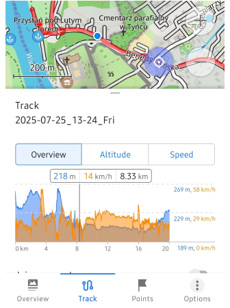
Distance Info for Track Overview
Added distance information for the selected point on the track graph as an additional parameter in the tooltip.
Added Translations for Help Menu
Help menu now includes translations for various languages (“en”, “ar”, “de”, “es”, “fr”, “it”, “nl”, “pl”, “pt”, “tr”, ‘ua’), making it more accessible to users worldwide.
Documentation is displayed in the language set “For the application” (after changing the language settings, a restart is required).
More Info for Map Context Menu
Added more information from OSM data to the map context menu for POIs.
Bug Fixes
- Fixed wrong radius location for Android Auto;
- Fixed issues with not updated ETA while not moving;
- Fixed crash while adding OSM Note;
- Fixed issue with Track appearance synchronization with Cloud;
- Fixed bug with intermitted Map Reset to Current Location When Zooming After Searching for a Place;
- Fixed issues with landscape grid layout;
- Fixed bug with importing of large GPX files while using OpenGL engine;
- Fixed issue with missing option to download standard map, contour lines map for entire USA;
- Fixed text color for the track appearance legend;
If you have suggestions for improving the Android version of the app, please get in touch with us. We appreciate and welcome your contribution to the further development of OsmAnd.

